Post Card From Oz2 Sept 1998
From our Queensland, Australia Trip
|
|
|---|---|
|
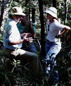
A DAY IN THE PARK. Our first field trip was an afternoon visit to Brisbane Forest Park (BFP) for an introduction to the Australian environment and for some practice of data collection techniques. BFP is a large expanse of publicly held land that includes National Parks, State Forest (Queensland Government land), picnic grounds and a water reservoir. It stretches from within 7 kilometres of the heart of Brisbane to a distance of about 40km away. As well as being the site of several local television transmitters and communications towers, Mt Coot-tha includes numerous picnic and other recreation facilities and is the nearest part of Brisbane Forest Park to the city. Mt Coot-tha has an elevation of 218m and is a 10-minute drive west of the University of Queensland. Here David Yates discusses foliage projective cover, a measure of the proportion of the ground that is covered by leaves (or, more generally, by vegetation). A simple way of estimating FPC is to sample a significant number of vertical point quadrats. For a tall community this may be done by using a sighting device and determining whether at the point sampled overhead there is sky, leaf or branch present.
| |
|
Go to: |
|