 (1)
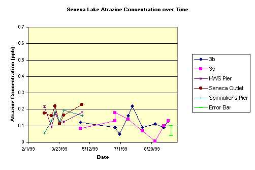
Atrazine concentrations in the lake during 1999 are at least 10x below the EPA's
mandated limit for safe drinking water and did not reveal any significant spatial
or temporal changes over the course of the study (see plot to right).
(1)
Atrazine concentrations in the lake during 1999 are at least 10x below the EPA's
mandated limit for safe drinking water and did not reveal any significant spatial
or temporal changes over the course of the study (see plot to right). Atrazine in Seneca Lake
Quick Links
Introduction:
Industrial, agricultural and other pollutants threaten our freshwater
supplies and can easily transform formerly potable water into substantial health
hazards. Atrazine is a perfect example. It is one of the most widely used herbicides
in the United States to control broadleaf and grassy weeds in corn, sorghum,
sugar cane, pineapple and other crops. Atrazine works by inhibiting the light-induced
decomposition of water in the chloroplasts of certain plants thus disrupting
photosynthesis. Atrazine has been shown to cause adrenal degradation and congestion
of the lungs, liver and kidneys. This makes it all the more disturbing that
it has been detected in surface water and groundwater at levels that exceed
the US Environmental Protection Agency's 3 ppb limit for safe drinking water.
David Eckhardt, a USGS hydrogeologist at Ithaca, detected Atrazine concentrations of 0.1 to 1.0 ppb in the Finger Lakes, concentrations that approach the EPA mandated limits for drinking water. Seneca and Cayuga Lakes had the highest measured atrazine concentrations compared to most of the other Finger Lakes, perhaps due to their larger percentage of agricultural land in their respective watersheds. This research focused on the concentration and source of Atrazine in Seneca Lake over time.
Methods:
Water samples were periodically collected from Seneca Lake to measure the Atrazine
concentration in the lake and selected tributaries (to isolate the primary waterborne
sources of Atrazine to the lake) from the early spring to the late summer of
1999 and again from the early spring to the late summer of 2000. The lake sites
were spatially distributed both around the margins of the lake and offshore
sites. At the offshore sites, both surface and bottom water samples were collected
and analyzed. The tributaries were selected from the 29 major subwatersheds
within the basin (see map) and represented a range
of basin size (15 to 100 sq. km) and landuse (Agriculture from 25 to 85% of
the landuse). During 1999, streams were flowing from the early spring to early
June, and sporadic afterwards. During the sporadic flow period, stream samples
were collected after major precipitation events. Stream flood was much higher
in 2000, and flowed throughout the study period. The difference is attributed
to significantly more rain in 2000 than 1999, over 23 inches of rain in 2000
during the study period compared to under 15 inches of rain in 1999 during the
study period. Atrazine concentrations were analyzed using the Atrazine RaPID
Assay Kit that utilizes an enzyme-linked immunosorbent assay to determine Atrazine
and related triazines (Omicron Environmental Diagnostics). The precision of
the procedure is 0.06 ppb and minimum detect limit is 0.05 ppb.
1999 Results:
(1)
Atrazine concentrations in the lake during 1999 are at least 10x below the EPA's
mandated limit for safe drinking water and did not reveal any significant spatial
or temporal changes over the course of the study (see plot to right).
Site 3s (surface sample) and 3b (bottom sample) are midlake and located between Kashong Creek and Reeder Creek. This site has a water depth of approximately 100 meters.
Perhaps the low concentrations detected by this study compared to Eckhardt's
data reflect the lack of precipitation and a corresponding lack of stream flow
during the summer of 1999.
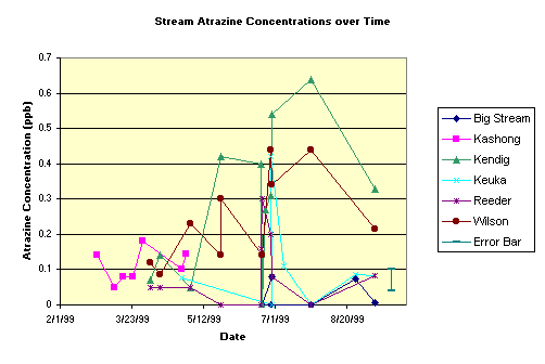 (2)
Atrazine concentrations in the streams are also low (see plot to left). A simple
mass balance model predicts that the average Atrazine input by these streams,
if extrapolated over the entire watershed, is sufficient to support the detected
concentrations in the lake.
(2)
Atrazine concentrations in the streams are also low (see plot to left). A simple
mass balance model predicts that the average Atrazine input by these streams,
if extrapolated over the entire watershed, is sufficient to support the detected
concentrations in the lake.
The plot does reveal temporal changes in Atrazine concentration with Wilson
and Kendig Creeks revealing the highest concentrations in mid-July, just after
the application of Atrazine to the farm fields in these subwatersheds. The concentrations
decrease after this peak and correspond to its declining use in the watershed.
The other less-agricultural streams do not reveal a change over time. The association
strongly suggests that the primary source of Atrazine to the lake is runoff
from agricultural activities. Similar concentration vs. time trends are observed
elsewhere, where runoff from farmland is the primary source.
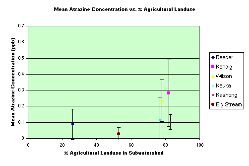 (3)
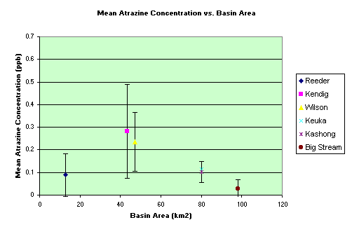
Plots of mean Atrazine concentration versus percent agricultural landuse
in the respective subwatershed, and mean Atrazine concentration versus
subwatershed size reveal a link between agricultural activity and Atrazine input
to the lake and no correlation between basin area and Atrazine input to the
lake (see map).
(3)
Plots of mean Atrazine concentration versus percent agricultural landuse
in the respective subwatershed, and mean Atrazine concentration versus
subwatershed size reveal a link between agricultural activity and Atrazine input
to the lake and no correlation between basin area and Atrazine input to the
lake (see map).
Kashong Creek and Keuka Outlet are the notable exceptions. Kashong Creek remained
completely dry during the month of July, when noticeable Atrazine was detected
in the other creeks. Thus, our sampling program missed any runoff after the
probable application of the herbicide in this watershed. Keuka Outlet drains
Keuka Lake, the adjacent Finger Lake to the west of Seneca Lake, and the majority
of the farmland between Keuka Lake and Seneca Lake is under the control of Amish
farmers. Thus, the upstream lake and unique farming practices may account for
this discrepancy.
2000 Results:
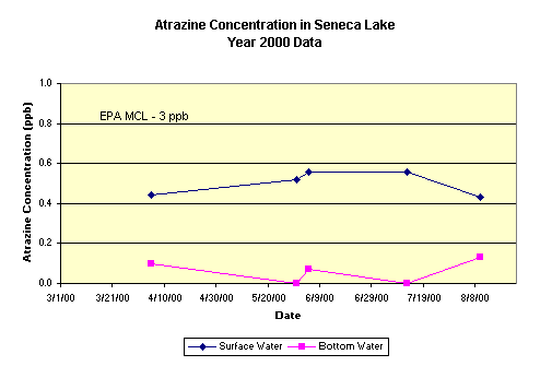 (1)
Atrazine concentrations in the lake during 2000 are still below the EPA's mandated
limit for safe drinking water but the surface water concentrations are significantly
higher (2 times higher) in 2000 than in 1999. (see plot to right).
(1)
Atrazine concentrations in the lake during 2000 are still below the EPA's mandated
limit for safe drinking water but the surface water concentrations are significantly
higher (2 times higher) in 2000 than in 1999. (see plot to right).
The lake samples were restricted to site 3 during 2000 because the 1999 data suggested minimal variability through out the lake. This may have been a mistake. The lack of variability in 1999 may reflect the lack of rainfall, thus runoff, to the lake in 1999. The year 2000 data reveal significant differences between the surface and bottom water concentrations. It suggests that we should collect samples from other sites across the lake in the future to look for spatial variability.
The 2000 surface water concentrations are comparable to those detected earlier by D. Eckhardt.
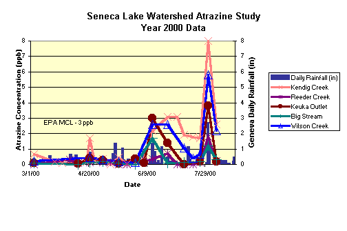 (2)
Atrazine concentrations in the streams during 2000 vary over the course of the
study (see plot to left). Concentrations are typically low and similar to 1999
values up to the end of May. After May, stream concentrations are significantly
higher than those detected in 1999. A number of values are very close to and
occasionally exceed the EPA's MCL of 3 ppb, with the largest detected concentration
of 8.0 ppb (Kendig Creek at the beginning of August).
(2)
Atrazine concentrations in the streams during 2000 vary over the course of the
study (see plot to left). Concentrations are typically low and similar to 1999
values up to the end of May. After May, stream concentrations are significantly
higher than those detected in 1999. A number of values are very close to and
occasionally exceed the EPA's MCL of 3 ppb, with the largest detected concentration
of 8.0 ppb (Kendig Creek at the beginning of August).
Spatial and temporal changes are probably due to two primary factors.
First, landuse is critical (see map). As in 1999, streams with a higher percentage of agricultural land revealed higher atrazine concentrations. Atrazine concentrations peak during June, July and August, after the suspected application of atrazine to the field.
Second, the amount of rainfall and the corresponding amount of surface runoff are also critical. The largest concentrations were detected in stream samples collected during or just after major rainfall events that resulted in major surface runoff (flooding) events. For example, the largest rainfall event, August 1 & 2, 2000, corresponds to the largest atrazine concentrations detected in each stream.
(3) Lake and stream concentrations were larger in 2000 than 1999. The primary difference probably relates to the amount and intensity of rainfall between the two years. During the sample period (3/1 - 8/24), less than 15 inches of rain fell in Geneva, NY, during 1999 whereas over 24 inched of rain fell in 2000 (data from New York State Agricultural Experiment Station). The largest storm in 2000 (8/1 & 8/2) dropped over 4 inches of rain in the area, twice as much rain as any other 2 day period during the study, and corresponded to the highest detected atrazine concentrations.
The climate changed from one of the driest to one of the wettest springs/summers on record. Clearly, more research is required to determine the atrazine loading to the lake during normal years.
Last Updated on 9/1/00
By John D. Halfman, Dept. of Geoscience
This research was supported by a grant from the NE Regional EPA Office (NE 99-2890-98-0)
to John D. Halfman. Additional funds were provided by Hobart & William Smith
Colleges and the National Science Foundation.
One purpose of this site is to provide Science-On-Seneca teachers a handy reference for the "atrazine story" at Seneca Lake. Feel free to contact John D. Halfman, Professor of Limnology, Hydrogeology & Environmental Geology, Hobart and William Smith Colleges or look at his web site for information on Seneca Lake.
Click here to get an excel file with the data used in this study.