 |
|
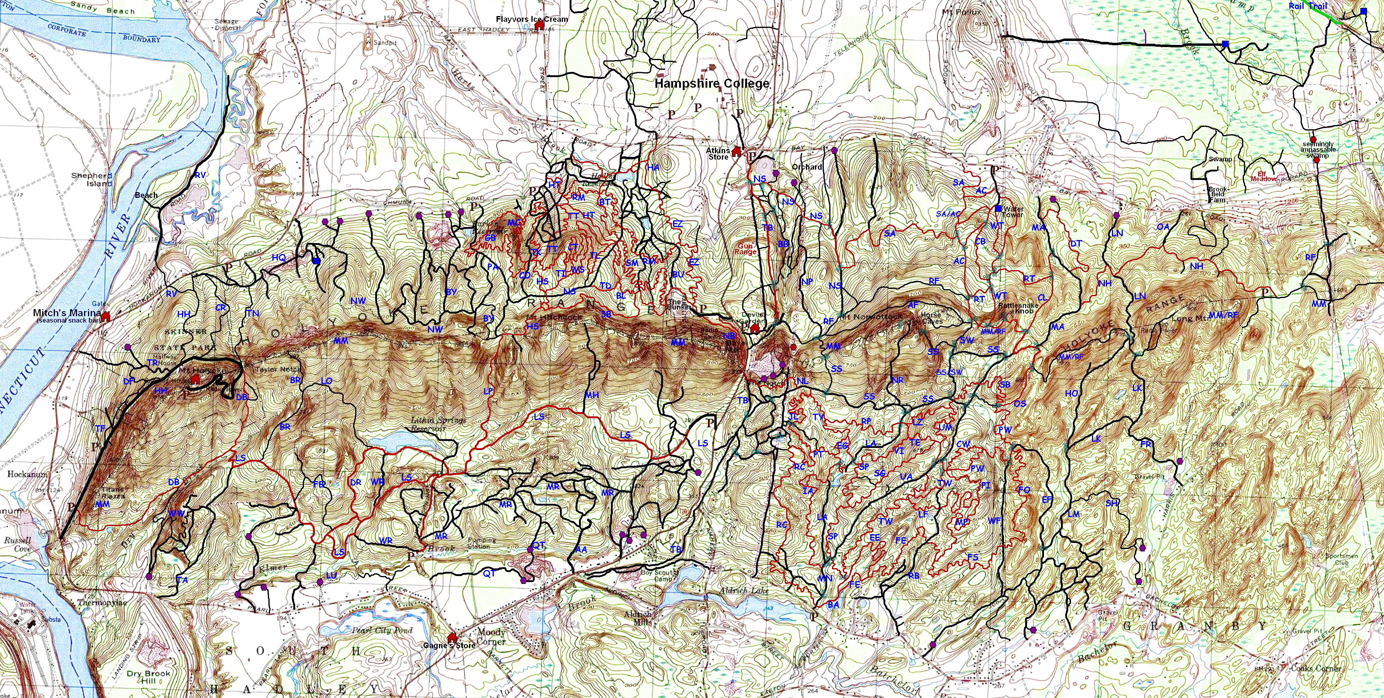
Mountain Bike Trail Guide to the Holyoke Range
| Code | Trail Name | Miles | Difficulty | Description |
| 3B | Bonnie's Birthday Bash | 0.8 | 5 | 3B is a single-track traverse beneath the cliffs of Bare Mtn. & Mt. Hitchcock, on the upper slopes of the Hadley trails (a.k.a., "Earl's Trails"). There are a few somewhat off-camber sections. |
| AA | Aldrich Access | 0.3 | 1 | AA is road that begins paved and turns into dirt and then into a jeep road. It is hard to find the way in if you don't know it already. |
| AC | Amherst Conservation |
0.8 | Up 2, Down 1 | AC is a jeep road that gradually climbs from just below the Bay Road water tower up to the Robert Frost Trail (RF). This trail is blazed in yellow. |
| AF | Anti-Frost Trail | 1.0 | Up 11, Down 7 | AF is a unidirectional single-track (east to west) because of several very steep sections near the west end. From the east end, you climb fairly steeply, then climb a bit more - after which you mostly descend. This was a fun advanced trail in 2003. {MIGHT NO LONGER BE RIDEABLE.} |
| BA | Better Access | 0.6 | 2 | BA is a single-track alternative to Main Access (MN) from the Batchelor Street parking area. It takes you to the base of Twister (TW) and then ends at the start of Serpentine (SP), on the other side of Upper Access (UA). |
| BB | Brookbank Trail | 0.6 | BB is a footpath with a couple stream crossings, and some steep sections with dug in steps. This trail is blazed in yellow. | |
| BL | Bunker Link | 0.3 | 6 | BL is a short connector that allows one to go from the Two Deer Trail (TD) to the trails around the military bunker (and the Notch) more quickly than the alternatives. |
| BR | Black Rock Trail | [BR has STILL not been fully evaluated.] This trail is blazed in blue. | ||
| BT | Big Tree Trail | 0.5 | Up 6, Down 4 | BT is very fun single-track, especially downhill, with many sharp turns and some fast descents for such a short trail. |
| BU | Bunker Road | 0.7 | 3 | BU is a little bit washed out at points, but is not a big challenge. E-Z Trail (EZ) is preferable up and down. |
| BY | Beary's Trail | 1.0 | Up 5, Down 3 | BY is mostly single-track, some of which used to be a logging road. The top is the only steep part, but most of the rest of the trail was torn up by fire breaks from the 2002 forest fire. {It may be very hard to even find this trail these days.) |
| CB | Ken Cuddebank Trail |
0.5 | Up 5, Down 4 | CB is a single-track that climbs from the Bay Road water tower to the Rattlesnake Traverse (RT). It requires some skill, but is not particularly challenging. |
| CL | Cliff Side Trail | 0.6 | Up 6, Down 4 | CL is a jeep road that is reverting to a single-track. It climbs from Mechanic Access (MA) to the M&M trail just east of Rattlesnake Knob. The trail is fairly washed out in places, and there is a tricky climb at the base of the trail. |
| CO | College Road (Berm Trail) |
0.5 | Up 3, Down 1 | CO is a well maintained old road at a reasonably relaxed grade for climbing. It is probably the easiest way up the northwest side of the range. The downhill is notable for the many berms (i.e., water bars), which can be used as big jumps if you are into that sort of thing, but which can easily be rolled over in a mellow manner. This trail is blazed in red. |
| CR | Conglomerated Rock |
0.6 | Up 6, Down 5 | CR is a new single-track that climbs from the trail near Hockanum Road to just above the Halfway House. It passes by Conglomerated Rock. This trail is blazed in red. |
| CT | Christmas Trail | 0.3 | 7 | CT is a technical, VERY off-camber single-track with many switchbacks that hugs the steep slopes near the top of Tinker Hill. It is quite unlike Tessman Loopm (TL) or Wall Street (WS), off of which it branches. |
| CW | Chad's Wicked Trail | 0.3 | 7.5 |
CW is a technical, VERY rocky single-track that goes over as many obstacles as it can over a short section of terrain. |
| DB | Dry Brook | 1.6 | Upper: Up 8, Down 6 Lower: 3 |
DB is a wide single-track with two parts. The lower part (west of LS) is very easy except for some steep technical climbs near the western trailhead (which are ignored in the rating of the lower part). The upper part is a rocky and sometimes steep climb up to Taylor Notch, which requires lots of skill and endurance. The short alternate loop (to the east) on this climb is not rideable. This trail is blazed in red. |
| DF | Devil's Football Trail |
0.2 | Up 7, Down 6 | DF is a short, steep single-track that climbs from near the base of the Tramway Trail (TR) climb and ends at Devil's Football (a big rock). This trail is blazed in blue. |
| DR | Dry Road | 0.5 | 2 | DR is not really a single-track, but it rides like one in places. It is a fun rolling ride in either direction. It can have some mud, but compared to the alternative trail, Wet Road (WR), it is bone dry. This trail is blazed in yellow. |
| DT | Dakin Trail | 0.7 | Up 3, Down 2 | DT is a single-track that is fast and fun going downhill, without much challenge apart from that added by speed. This trail has commonly been called "Gina's Trail". This trail is blazed in yellow. |
| EE | Entrance Exam | 0.6 | 8 | EE is a very technical and potentially dangerous single-track that starts at the base of Twister (TW) and heads east to meet with Far East (FE). It starts out very easy, but it then becomes one of the most technical trails in the Holyoke Range. The trail is now rideable (albeit very challanging) in both directions. |
| EF | East Farm Road |
1.1 | 4 | EF is a jeep road that has not been fully cleared after long disuse. There is one particularly difficult short climb/descent, but overall it is not particularly interesting riding. Ratings are setting aside the one tough section, which would raise the ratings to a 7 or 8. |
| EG | Em's Gem | 0.4 | 4 | EG is a single-track that allows one to bypass the ever-rising beaver pond across Lower Access (LA). EG is generally not very hard, but it is twisty and fun. EG connects the middle of Pond Trail (PT) to the west end of Serpentine (SP). |
| EZ | E-Z (Emma-Zeke) Trail | 1.0 |
2 |
EZ is a very pleasant single-track through a pine forest. There are lots of turns in the trail to make it a bit more interesting, but it is basically a simple climb to "The Bunker" and a quick fun descent. There are a several dead end side trails off the main path. |
| FB | Falling Bridge Trail |
0.7 | 5 | FB is a single-track that presents a more challenging alternative to staying on Lithia Springs Trail (LS). FB climbs and then descends from either direction, though the climb is easier west to east. Despite the name, the bridge is ridable (or was in 2004, at least). |
| FE | Far East Trail | 1.3 | 6 | FE is a challenging single-track that winds through great terrain. You can use Missing Persons (MP) and then Lost & Found (LF) to make a nice loop up the south side of the range. FE starts just after the bridge on Better Access (BA). |
| FO | Far Out | 2.0 | Up 8, |
FO is an exceptionally good single-track in the spirit of Missing Persons (MP). It begins at the intersection of East Farm Road (EF) & Pete's Wicked Trail (PW), and runs down to West Farm Road (WF), where it connects with the end of Far Side (FS). |
| FR | Forgotten Road |
0.5 | Up 4, Down 3 | FR was two different jeep roads. The first connects Link Road (LR) to Harris Mtn. Rd. still appears to be open. The second section connects that to the M&M trail (MM). The first road descends from LR, and is somewhat challenging. The second has probably not been riden since 2004. {A house now stands where these two parts connected.} |
| FS | Far Side | 1.5 | 7 | FS is an exceptionally good single-track in the spirit of Missing Persons (MP). It begins near the south end of Missing Persons (MP) and winds down to West Farm Road (WF), where it connects with Far Out (FO). |
| GB |
Glenna Bell Trail |
1.6 |
5 |
GB is a lovely winding single-track that goes to the top of Little Tinker Hill, then down to Parker Access (PA), and then loops back to the base of Margin Call (MC). Like most of the surrounding trails, it's not particularly technical, but it is an excellent trail with great flow. |
| HA | Hampshire Access | 0.2 | 1 | HA is an easy single-track starting across Bay Road from the back (dirt) enterance to Hampshire College. |
| HH | Halfway House Trail |
0.6 | Up 4, Down 2 | The bottom half of HH is a wide single-track that climbs fairly gradually to the Halfway House. The top half is not recommended for riding. This trail is blazed in blue. |
| HO | Hollow Road | 0.7 | Up 6, Down 5 | HO is a somewhat rocky old road. It is an easier climb and descent than Link Road (LK). This trail is blazed in blue. |
| HQ | Hockanum Quarry Road |
0.4 | 1 | HQ runs from the base of Taylor Notch Trail (TN) over to the base of Northwest Passage (NW). Most of this is passing through an old quarry of sorts. |
| HS | Hitchcock Single-track |
0.6 |
Up 6, Down 4 | HS is a lot of fun in either direction. The climb is on fairly soft dirt, but it is quite steep in places. The descent is fun without being all that challenging. |
| HT | Hunter Trail | 0.7 | 4 | HT is a single-track that traverses some of the northwest quadrant. There is one steep section at the eastern end of the trail. This is a particularly pretty trail. |
| IA | IMBA Access | 1.3 | 3 | IA is a single-track that serves as an alternative to Lower Access Road (LA). It is a fairly easy but pleasant way in, and it is really quite a fun way to go out. Going into the range it starts just after the small stream crossing on Main Access (MN). Leaving the range, it starts just before you rejoin the road section of Lower Access (LA) at the outlet of the beaver pond. |
| JL | Jacob's Ladder |
0.6 | 8 | JL is a superb and very challenging, single-track. The middle section (added in 2003) is a brilliant collection of technical moves that are all rideable in both directions. The northern end of the trail is tough, but not as tough as it used to be. |
| LA | Lower Access |
1.3 | 4 | LA is a road with a stretch of single-track to go around a beaver pond. Much of LA tends to get very wet. Many alternative single-track trails provide for much more interesting riding. |
| The LAB (Lactic Acid Bath) ** | ** See the entry for the upper part of Water Tower Trail (WT). | |||
| LF | Lost & Found Trail |
0.3 | Up 7, Down 6 |
LF is a single-track that is challenging in either direction. Uneven ground with rocks and off-camber sections make it interesting. |
| LK | Link Road | 0.8 | Up 8, Down 6 | LK has a lower and an upper part. The lower part is somewhat challenging, and the upper part is really quite challenging. Ratings are based on the upper part. This trail is blazed in red. |
| LM | Long Mountain Road |
1.2 | 2 | LM is a well-traveled approach to other trails. It has little gain in elevation, but it is subject to mud puddles. |
| LN | Long Mountain Road North |
0.5 | Up 6, Down 5 | LN has an upper and a lower part. The lower part is easy either way. (0.3 miles / Difficulty: Up 2, Down 2) The upper part is a fun and technical road with lots of turns. It is basically a significantly washed out road with plenty of rocks and roots. |
| LO | Lithia Overlook Trail |
0.7 | Up 10, Down 8 | LO is a challenging single-track descent that is fun for good downhill riders. Trying to go up LO is much less fun. This trail is blazed in blue. |
| LP | Low Place Trail |
0.5 | Up 9.5, Down 8 | LP is a road which turns into a single-track as it goes up to The Low Place on the ridge. This is a tough trail in either direction. The top section seems to be unrideable going up, though I've heard of someone doing it. There are plenty of fixed rocks, and lots of loose basalt rock chips. Take care in either direction. This trail is blazed in blue. |
| LS | Lithia Springs Trail |
1.9 0.4 1.2 |
Eastern: Up 7, Down 5 Middle: 10 Western: 5 |
LS is a long trail that can be divided into three parts: Western, Middle, and Eastern. The Western part is a jeep road that runs from Dry Brook Trail (DB) to Wet Road (WR). Most of this part is fairly easy, though there are a few somewhat challenging and tiring climbs. The Middle part is a new single-track that leaves Wet Road (WR) to go over a hill and end on Lithia Springs Road. This has a short section which is unrideable in either direction. The Eastern part is a jeep road that goes from the gates of Lithia Springs Reservoir to Route 116. The part near 116 can get muddy, and there is one tough climb going westward. This trail is blazed in yellow. |
| LU | Lukasik Access | 0.6 | Up 6, Down 5 | LU was a great way to enter the southwestern part of the range, especially if you appreciated great soup (at the deli). The trail ran through the game farm, then turned into a single-track that lets out onto the lower part of Wet Road (WR). There is one steep climb on the way out, but it is rideable in both directions. (This one steep section is the reason for the trail's difficulty rating.) The trailhead off of WR is quite hard to see. {This may no longer be a ridable trail.} |
| LZ |
Lizard King |
0.5 |
8 |
LZ is another great single-track. It is similar in character to Jacob's Ladder (JL) and Missing Persons (MP). It has amazing rock work, and it is all quite rideable if you've got the skills. |
| MA | Mechanic Street Access |
1.3 | Up 3, Down 2 | MA is a jeep road. The lower parts are very easy, but it gets a bit more challenging as you near the ridge. However, it is one of the easiest ways to get up to the ridge. |
| MC | Margin Call | 0.5 | 7 | MC is a single-track on Little Tinker Hill with many switchbacks and a lot of seriously off-camber riding. The climb is quite tiring. |
| MH | Mount Hitchcock Road |
0.5 | Up 11, Down 9 | MH is an old fire tower road. Much of this trail is unrideable going up because of big rocks and a steep grade. It is a very challenging (& seemingly dangerous) descent as well. The trail ascends to an unrideable section of the M&M Trail (MM), so why would you bother? This trail is blazed in red. |
| MM | Metacomet & Monadnock (M&M) Trail |
MM is a very long trail that passes through the Holyoke Range. Most of this trail in the Holyoke Range is not rideable because it goes along the ridge and over every peak. This trail is blazed in white. | ||
| MN | Main Access | 0.3 | 1 | MN is simply the wide jeep road that is the primary entrance to the trails from Batchelor Street. MN splits into Upper Access (UA, going right on the way in) and Lower Access (LA, going left). |
| MP | Missing Persons | 1.3 | Up 8, Down 7 |
MP is an amazing technical single-track that links the eastern ends of Far East (FE) and Lost & Found (LF). It is more interesting and challenging than either of these, which is saying a lot. |
| MR | Maze Road | 1.4 | Mostly 2 Briefly 6 |
MR is a jeep road that winds its way through a maze of other jeep roads. Much of MR is smooth dirt and grass, but some parts are rocky. So, most of it is very easy but a short stretch on the east end is quite challenging. It is subject to flooding, and it is extremely easy to get lost. |
| NB | Notch By-Pass | 0.4 | 6 | NB is a single-track that runs along Route 116 and Military Road to connect the Hadley trail system (i.e., Earl's Trails) with the Granby trail system (i.e., Batchelor St. area). It is a narrow trail mostly cut into the side of a steep hill. |
| NH | North Harris Trail |
1.5 | East 5, West 4 | NH is a road that is generally quite tame, but has a few tricky parts to it. An eastern stretch of it can get quite muddy, but certainly not impassible. This trail is blazed in yellow. |
| NL | Notch Link | 0.5 | 7 | NL is a single-track that connect Route 116 to South Side (SS) trail near the top of Jacob's Ladder (JL). It is quite technical, but there's a jeep road alternative which is considerably easier (though still with a tricky climb going eastward). |
| NP | Northeast Power Line Road |
0.8 | Up 4, Down 3 | NP is a seldom used jeep road that runs mostly parallel (but sometimes under) the big power lines. It is a pleasant climb or descent, though the clear part of the road gets quite thin at points. |
| NR | Norwottock Road |
0.5 | Up 11, Down 8 | NR is the old jeep road to the recently removed fire tower on top of Norwottock. As you might imagine it is entirely composed of good sized rocks, which make it unrideable going up. With some guts and a bit of skill, one can get down it. |
| NS | North Side Road |
1.1 1.4 |
Eastern: Up 4, Down 3 Western: Up 6, Down 4 |
NS is really two separate trails, one East and one West of 116. These are separated by about .5 miles on Bay Road. They ought to have different names, but I didn't name them, so don't blame me. The Eastern trail goes from near Atkins Farm Store up to the Robert Frost Trail (RF). This is mostly jeep road with a bit of single-track in the middle. It is easy except for some root covered parts in the single-track. The Western trail is a jeep road that starts at the Lower Hadley Reservoir and goes up to Parker Road (PA) near The Low Place. The last part of the climb on NS is washed out and challenging, but the trail is generally easy. The upper part of NS can get quite muddy, but not impassible. This trail is nominally blazed in yellow. |
| NW | Northwest Passage |
NW was a combination of new fire roads, old logging roads and new single-track, going from near the Low Place to Hockanum Quarry. The new fire roads are more like fire breaks and so they make for tough riding. {The single-track has deteriorated and has essentially disappeared.} | ||
| OA | Orchard Street Access |
0.2 | Up 2, Down 1 | OA is a fairly quick climb from Bay Road to North Harris Trail (NH). The trail head on Bay Road is a bit hard to see and the trail is not much used. |
| OS | Other Swamp Trail |
0.4 | Up 7, Down 5 | OS is a single-track, half of which is very rocky & technical, and half is fairly smooth cruising. The intersection with Pete's Wicked Trail (PW) is roughly the divider between these parts. There is one tough short climb going eastward, which is up. |
| PA | Parker Road | 0.9 | Up 5, Down 4 | PA is a jeep road going from Chmura Road up to The Low Place. The first climb is considerable, but not all that difficult. There is then a fairly flat stretch. Beginning at the intersection with NS, the last section is a somewhat technical climb, particularly when it is wet. This trail is blazed in blue. |
| PI | Private Investigation | 0.5 | Up 7, Down 6 |
PI is a single-track that climbs from the middle of Missing Persons (MP) to the south end of Pete's Wicked Trail (PW). |
| PT | Pond Trail | 0.4 |
Mostly 4 |
PT is a single-track that goes from Lower Access (LA) at the Beaver Pond up to the power lines. The trail's upper part is now rarely used due to the extensions of Rollercoaster (RC) and Jacob's Ladder (JL). |
| PW | Pete's Wicked Trail |
1.2 |
8 |
PW is a fun and challenging single-track going from Upper Access (UA) over to the Other Swamp Trail (OS). The trail has some fairly technical elements scattered throughout, but also has less challenging stretches. |
| QT | Quarry Trail |
1.2 | Up 4, Down 3 | QT goes from Lithia Springs Road (LS) to Maze Road (MR), through an old quary of sorts. The mountain part is a jeep road, while most of the flat part is single-track. The trail head on Lithia Springs road is hard to see (it's near where the pavement ends), and the trail itself is hard to follow (where it even exists as such). |
| RB | Red Barn Road |
1.0 | Up 3, Down 2 | RB is a somewhat overgrown jeep road that can get swampy near the bottom of the forest section. The climb is fairly gradual. The lower section of the road is through (or around the edge of) two large farm fields, which are not always mowed. |
| RC | Roller Coaster |
2.0 | Up 6, Down 5 | RC is a single-track trail that is an intermitently challenging, yet fun climb and an extremely fun descent. The central part feels like a bit of a roller coaster in either direction. The new bottom section of RC is very nice single-track with some technical spots. It avoids the old jeep roads. The new top section takes you right to the middle of Pond Trail (PT) and then to the start of Jacob's Ladder (JL), avoiding the need to get on the powerlines. |
| RF | Robert Frost Trail |
Up 5, Down 4 | RF is a very long trail that begins at the Notch and goes far beyond the Holyoke Range. The sections within the range are single-track, and often coincide with the M&M trail. The part which does not coincide runs from just east of the Notch to just east of the Horse Caves. This section is somewhat challenging. This trail is blazed in orange. | |
| RM | Rambunctious | 1.3 | 4.5 | RM is a single-track traversing the lower slopes of the Hadley trails (a.k.a., "Earl's Trails"). The trail is twisty and fun without many difficult spots. |
| RP | Raptor | 0.6 | 5 | RP is a single-track through some beautiful terrain, connecting the bottom of Technical Trail (TT) to the middle of T-Rex (TY) just above its climb. |
| RT | Rattlesnake Traverse |
0.8 | Up 3, Down 2 | RT is a simple single-track that climbs gently from Cliffside Trail (CL) to Water Tower Trail (WT) and then to the Robert Frost Trail (RF). Up is fairly simple and down is fast and fun. |
| RV | River Trail |
1.3 | Up 5, Down 3 | RT goes from near the base of Halfway House Trail down to River Road, and the follows River Road upstream for about a mile. The top part is single-track. River road is a dirt road. The climb up RT from Hockanum Road is a bit challenging. RT provides access to a nice beach on the river. |
| SA | Sweet Alice |
1.6 | 5 | SA is a combination of jeep road and single-track with three basic sections. The single-track from Bay Road to the Amherst Conservation Trail (AC), but it is not well maintained and is seldom used because of an invisible or impassible trail head. The middle section coincides for a stretch with AC and climbs gradually. The fun section goes from AC to North Side Road (NS). This can get a bit muddy in places, but it is fun without being very difficult. This trail is blazed in blue. |
| SB | Southern Belle | 0.9 | 7 | SB is an entertaining and mostly smooth single-track with a few technical sections and some climbing. It starts at the top of Pete's Wicked Trail (PW), crosses Other Swamp Trail (OS), and then ends at the top of Lizard King (LZ), allowing one to make more loops while avoiding old muddy roads. |
| SG | Serpent God | 0.7 | Up 8, Down 7 | SG is a single-track that is quite technical in places. It connects the middle (high point) of Serpentine (SP) to the middle (high point) of Technical Trail (TT). Everything is rideable up and down, but up requires both skill and stamina. This is a superb trail for technical riding in either direction. |
| SH | Shotgun Single-track |
1.0 | East 4, West 5 | SH is a spur off of Long Mountain Road (LM). It has some charm as a trail, but it dead ends. |
| SM | Swiss Miss | 1.5 | 5 | SM is a spectacular single-track trail that is tight in places but cruises well and is not particularly technical. It traverses the mid-altitude slopes of the Hadley trails (a.k.a., "Earl's Trails"). |
| SP | Serpentine | 0.9 | 7 | SP is simply a very good technical single-track. It has lots of twists and obstacles, some tricky short climbs, and some smooth sections. It is equally fun and challenging in either direction. |
| SS | South Side Trail |
0.2 1.3 0.3 |
Western: Up 6, Down 5 Middle: 6 Eastern: Up 10, Down 9 |
SS is actually a set of connected jeep roads (and a bit of single-track) going from the M&M Trail (MM) on one side of Norwottock's summit to the M&M Trail on the other side of the summit. The Western section of SS (MM - NL) is a fairly easy way to get from the South side of the range to the North side. The middle section of SS (NL - SW) has one difficult climb/descent, but is generally not too tough even though it has character and requires attention. The Eastern part of SS (SW - MM) is a steep and technical single-track that may be best thought of as downhill only (and might be fun if there were a decent way to get to the top of it). {The eastern part may not even be maintained or passable any longer.} Confusingly, SS & SW are the same path for a stretch, and then SS also goes east from SW toward Mechanic Access (MA). This trail is blazed in blue. |
| SW | Swamp Trail |
0.5 | Up 9, Down 7 | SW begins as a jeep road and then turns into a single-track as it begins to climb to the Robert Frost Trail (RF). The first section goes from one part of South Side Trail (SS) over a small hill to a fork in SS. This is modestly challenging. The second section, which climbs to the ridge, is a very difficult but perhaps rideable climb. This trail is blazed in red. |
| TA | Thermopylae Access |
1.0 | Up 3, Down 2 | TA is a jeep road that is a fairly easy way to enter the range in the southwest quadrant. |
| TB | Trolley Bed Trail |
1.0 1.6 |
Northern: 1 Southern: 2 |
TB is the easiest trail to the Notch and over the range from either direction. Sandy patches can make some parts more difficult on the south side and at the base of the north side. From the top of TB on the north side, take the big dirt road to 116 and then take the first trailhead on your left. The southern half of TB will be your first right off this trail. This trail is blazed in yellow. |
| TD | Two Deer Trail |
0.4 | Up 5, Down 3 | TD is a short alternative to the top part of the climb on North Side Trail (NS). Parts are single-track and parts are like a very old jeep road. The climb up is not clearly easier or harder than NS, but it is different in character because it has one very steep section but no rocks. |
| TE | Technical Trail |
0.5 | Up 7.5, Down 6 | TE is a single-track built for mountain biking and running between Upper Access (UA) & Lower Access (LA). Eastbound is the upwards direction. TE is what it says it is, a technical trail that has lots of twists and fixed rocks. It is not the most technical trail in the range, but the name isn't wrong. |
| TF | Two Forest Trail |
0.4 | TF paralells the paved "Mountain Road" (going to the top of Mt. Holyoke) from the lower gate to the Halfway House, passing by Devil's Football. This trail is blazed in yellow. | |
| TI | Tinker Trail |
0.6 | Up 5, Down 4 | TI is a single-track that runs from North Side Trail (NS) up slightly to the top of Tinker Hill and then down significantly toward the old ski area. The trail is technical enough to keep one's interest piqued. Although the top of the trail is in the middle, I call the generally southward direction "Up". |
| TK | Tinker Toy | 0.7 | 5 |
TK is a single-track that runs from the bottom of Margin Call (MC) back up to the top of MC, but by a different route, of course. It crosses wider trails a couple times, and it is easy to lose the trail at the base of College Road (CO). TK is steep at times, but not especially technical. |
| TL | Tessman Loop | 0.8 | 4 | TL is a twisty single-track, but it is not particularly technical. Some climbs are a bit steep and it is tiring. The trail simply loops off of Wall Street (WS) on the slopes of Tinker Hill and ends about where it starts. |
| TN | Taylor Notch Trail |
0.6 | Mostly 5, Top 10 |
TN begins near the roadside parking area on Hockanum Road (Route 47) and climbs, sometimes very steeply to Taylor Notch, where the paved "Mountain Road" crosses to the south side of Mt. Holyoke and where Dry Brook Trail (DB) meets the M&M Trail (MM). This trail is blazed in yellow. |
| TR | Tramway Trail |
0.6 | Up 3, Down 2 | TR is a fairly gradual switchback jeep road that climbs from Hockanum Road (across from Mitch's Marina) up to the Halfway House. It is a pretty and pleasant climb without any technical sections. This trail is blazed in red. |
| TT | Tricky Turn Trail |
0.8 | Up 6, Down 5 | TT is a very nice single-track that cuts across the old ski area. The central feature of TT is a switchback climb made for mountain biking. Other than this great section, the trail is pleasant but not technical. (Difficulty ratings are based on the technical switchback section.) |
| TW | Twister | 1.0 | Up 7, Down 6 | TW is a great technical single-track made for mountain biking. The trail is very twisty with rocks, roots, and logs interspersed to add challenge. |
| TY | T-Rex | 0.5 | Up 6, Down 4 | TY is a fun single-track connecting the middle of Em's Gem (EG) to the top of Jacob's Ladder (JL). The difficulty rating is due to one short climb with several quick turns. |
| UA | Upper Access |
1.2 | Up 6, Down 5 | UA is a jeep road with some challenging, washed out, rocky sections. |
| UM | Unsolved Mysteries | 0.6 | 5 | UM is a twisty and fun single-track connecting the top of Lizard King (LZ) with the middle of Technical Trail (TE), a short distance from the top of Serpant God (SG). |
| VI | Viper | 0.5 | Up 7, |
VI is a single-track connecting the top end of Serpentine (SP) with the bottom end of Technical Trail (TE). |
| WF | West Farm Road |
1.4 | 1 | WF is a jeep road that climbs very gently from a somewhat concealed on Batchelor Street to the middle of Pete's Wicked Trail (PW). There are many downed trees across the trail and it is often very muddy. |
| WR | Wet Road | 1.0 | Up 7, Down 6 | WR is another jeep road from Lithia Springs Road to Lithia Springs Reservoir. The first part of WR, which traverses the base of the range, generally stays fairly dry and is an easy ride for anyone. The second part of WR starts at a small clearing where Lithia Springs Trail (LS) intersects it. The second part has several major stream crossings and in wet conditions WR is virtual a river in its own right. This is not a well maintained road and riding it can be quite challenging. |
| WS | Wall Street | 0.7 | 4 | WS is a twisty single-track, but it is not particularly technical. Some climbs are a bit steep and they can be tiring. The trail simply loops off of Tinker Trail (TI) and ends about where it starts. |
| WT | Water Tower Trail |
1.0 0.2 |
Lower: Up 5, Down 4 Higher: Up 9, Down 8 |
WT is partly a single-track and partly a jeep road. It climbs from the Bay Road water tower up to the M&M trail (MM). The trail is only moderately challenging until Rattlesnake Traverse (RT) branches off to the west, but the higher part (above RT) is almost a downhill only trail. The top section is also referred to as "The LAB" (short for "Lactic Acid Bath"). I am told that it can be ridden going up, if you've got mad skills and big lungs. This trail is blazed in yellow. |
| WW | Wild West | 0.9 | Up 11, Down 9 | WW is mostly a very technical unidirectional single-track located between Thermopylae Access (TA) and Dry Brook Trail (DB). It is a good trail for very skilled riders who enjoy beautiful views and steep downhills with rocks. There are several somewhat scary drops. There is also a network of old roads that covers much of the same ground, but which can be ridden in either direction. When it was built, this trail was blazed in orange, though I have some doubts that WW has been maintained over the past decade, so it may no longer exist (for all intents and purposes). |