Hobart and William Smith Queensland Term 1996:
North Stradbroke Island Field Trip
- Background Information on North Stradbroke Island
- Field Work.
- Photos of Animals and Plants
- Links to Related Sites
 North Stradbroke Island, located in Moreton Bay is a 45 minute drive
and an hour's ferry ride from Brisbane. The island is
about 32 km in length and 11 km at its widest point. It consists almost
entirely of sand with rocky outcrops at Point Lookout.
North Stradbroke Island, located in Moreton Bay is a 45 minute drive
and an hour's ferry ride from Brisbane. The island is
about 32 km in length and 11 km at its widest point. It consists almost
entirely of sand with rocky outcrops at Point Lookout.
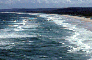
Looking south along the west coast of North Stradbroke Island.
The sands which make up the island originate in the highlands of eastern
New South Wales. As these areas erode, the sands are carried
seaward and then up the coast by ocean currents.
 Though there are rocky outcrops at Point Lookout (the northern end of the
island) and at Dunwich (center of the west side), sand dune systems dominate
the island. The sands of the island are mined by
Consolidated Rutile, Ltd. which has leases on much of the island's
land. They process 40 million tons of the island's sand recovering a very small
percentage of rutile, zircon, and ilmenite. Silica sand which is used in the
production of glass is also mined at a site north-east of Dunwich.
Though there are rocky outcrops at Point Lookout (the northern end of the
island) and at Dunwich (center of the west side), sand dune systems dominate
the island. The sands of the island are mined by
Consolidated Rutile, Ltd. which has leases on much of the island's
land. They process 40 million tons of the island's sand recovering a very small
percentage of rutile, zircon, and ilmenite. Silica sand which is used in the
production of glass is also mined at a site north-east of Dunwich.
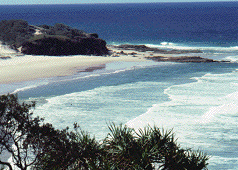
Near Point Lookout, North Stradbroke Island.
As might be expected on a sand island, there are several fresh
water lakes, the largest being Brown Lake and Blue Lake.
North Stradbroke has the most diverse fauna of all islands in Moreton
Bay which suggests that it might have been connected to the mainland more recently
than neighboring Moreton Island.
 The Stradbroke trip incorporated both marine and terrestrial
field work. The program began with
studies of the zonation of marine organisms in the intertidal zone at Polka Point
near the
UQ School of Marine Science Field Station in Dunwich where we stayed. This
involved data collection (primarily species counts) using quadrats
in five different zones along a
perpendicular to the shoreline. Analysis of these data showed how the
distribution of species changes in the region from the low to high water
lines.
The Stradbroke trip incorporated both marine and terrestrial
field work. The program began with
studies of the zonation of marine organisms in the intertidal zone at Polka Point
near the
UQ School of Marine Science Field Station in Dunwich where we stayed. This
involved data collection (primarily species counts) using quadrats
in five different zones along a
perpendicular to the shoreline. Analysis of these data showed how the
distribution of species changes in the region from the low to high water
lines.
Dr. Ian Tibbetts describes the process of zonation
at Polka Point.
Sue Flanders' Journal Entry:
2:00pm, 14 October 1996,
Polka Point, NSI. 21° 29' 48" S; 153° 23' 59"
 Conditions:
- sunny
- rocky shore
- semi-diurnal tides (uneven)
- wind (SE) quite strong contributing to water loss
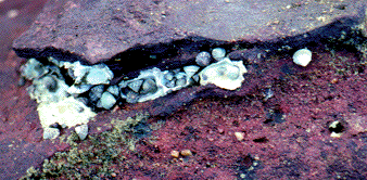
Bembecium on rocky outcrop in the intertidal zone at Polka Point.
 Why Live on Rocky Shores?
- shelter from predation
- substrate
- where they evolved ("They are where they are because they are where they are.")
- highly productive
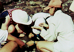
C. Parker '98 and A. Konkle '97 examine organisms in a quadrat in the intertidal
zone.
Many organisms are mobile feeders; e.g., molluscs, snails.
Their movement slows down at low tide.
They must be able to survive through sun, wind, high temperature.
Others are sessile, e.g., oysters (bivalves) in which
half is attached to substrate, the other half feeds
feed on bacterial matter, decayed organic matter.
Zonation: different species of organisms in
different bands along the shore. Shore to water:
snails, oysters covering part of the rocks, oysters covering rocks entirely.
Zonation Survey Methods
- place quadrat (lob gently, randomly)
- describe site: what percent sand, rock, pool area?
- quantify organisms in quadrat; search surface only;
discriminate live/dead; only count live
- sketch organism
- do this for all levels of shore
- note of representative organisms; what lives where
- return all rocks to original positions
- Is there a pattern on the shore? (ANOVA: 5 x 6 matrix)
- Caution: blue-ringed octopus; sharp oysters
 Sample 1:
Location: Just below the strandline---surface search:
70% sand cover, 30% rock, 0% pool, 0% gravel.
Sample 1:
Location: Just below the strandline---surface search:
70% sand cover, 30% rock, 0% pool, 0% gravel.
Observations: Seaweed, shells, rocks strewn about.
Strand line has full rock coverage---holes in rocks
for organisms to hide in. Sand coverage increases immediately
after strand line. Green algae found in seaweed--"jumpers" in algae.
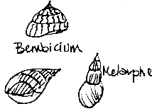
Sketches of Bembecium and Melaraphe by S. Flanders '98.
 Informal discussions of the marine life and environmental processes
in the intertidal zone were lead by David Graham, a doctoral student in
the School of Marine Science at UQ. Here David discusses the daytime activity
of fish in the intertidal zone before students used a seine net to sample the
area.
Informal discussions of the marine life and environmental processes
in the intertidal zone were lead by David Graham, a doctoral student in
the School of Marine Science at UQ. Here David discusses the daytime activity
of fish in the intertidal zone before students used a seine net to sample the
area.
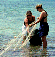 A. Burke '97 and N. Wheeler '97 with the seine net. Both day and night seinings were
done at consecutive high tides with the data collected showing much more
activity by a wider
variety of species at night.
Species captured
during the day were mullet, garfish,
whiting, flathead,
porcupine fish, and
silver biddy. Those caught at night included mullet,
hardy head, gerres, garfish,
whiting, bream, flathead,
puffer fish, cuttlefish, and small rays.
A. Burke '97 and N. Wheeler '97 with the seine net. Both day and night seinings were
done at consecutive high tides with the data collected showing much more
activity by a wider
variety of species at night.
Species captured
during the day were mullet, garfish,
whiting, flathead,
porcupine fish, and
silver biddy. Those caught at night included mullet,
hardy head, gerres, garfish,
whiting, bream, flathead,
puffer fish, cuttlefish, and small rays.
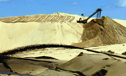 The terrestrial component of the trip began with a
visit to Consolidated Rutile Ltd, a large sand mining company.
The sands of the island are mined because they
are rich in rutile, zircon, and ilmenite. Rutile and ilmenite are sources
of titanium oxide pigment used in paint, plastics and rubber. Zircon imparts glazes
to tiles and ceramics.
The terrestrial component of the trip began with a
visit to Consolidated Rutile Ltd, a large sand mining company.
The sands of the island are mined because they
are rich in rutile, zircon, and ilmenite. Rutile and ilmenite are sources
of titanium oxide pigment used in paint, plastics and rubber. Zircon imparts glazes
to tiles and ceramics.
The mining process at CRL.
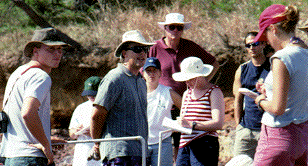
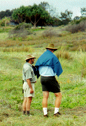
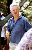 Students had
the opportunity to see and discuss the recent history of a variety of land
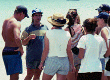
rehabilitation schemes. Here, Peter Foote, CRL's revegetation specialist,
converses with students about current and practices and legislation
regarding land rehabilitation on North Stradbroke Island.
Students had
the opportunity to see and discuss the recent history of a variety of land
rehabilitation schemes. Here, Peter Foote, CRL's revegetation specialist,
converses with students about current and practices and legislation
regarding land rehabilitation on North Stradbroke Island.
 Data collection using point-centered quarter methods to determine
relative density, basal area, and cover was carried out at Brown Lake
to illustrate successional stages in fire-adapted forests.
Data collection using point-centered quarter methods to determine
relative density, basal area, and cover was carried out at Brown Lake
to illustrate successional stages in fire-adapted forests.
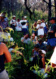
Here students and Professor Yates identify the plant species found
in a survey of a hillside that was burned less than two years earlier.
(Notice the burned vegetation in the background.)
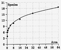 Species-area data were also collected using nested quadrats for plants at
Brown Lake in an area burned within the
last two years. A surprising number of species were present.
The results showed
the pattern of an increasing area accompanied by an increasing number of species
at a decreasing rate which were described by the power curve S = 6.5A^0.25 shown in
this graph.
Species-area data were also collected using nested quadrats for plants at
Brown Lake in an area burned within the
last two years. A surprising number of species were present.
The results showed
the pattern of an increasing area accompanied by an increasing number of species
at a decreasing rate which were described by the power curve S = 6.5A^0.25 shown in
this graph.
 Stradbroke is also known for its peat swamps or "bogs". Eighteen Mile Swamp
on the eastern side of the island is the largest of its type in Queensland.
The peat layer in the swamp a bout a meter in depth and the water table is
often close to the surface.
Stradbroke is also known for its peat swamps or "bogs". Eighteen Mile Swamp
on the eastern side of the island is the largest of its type in Queensland.
The peat layer in the swamp a bout a meter in depth and the water table is
often close to the surface.
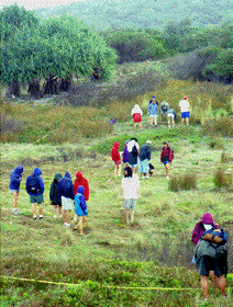
Species-area data collection took place using nested quadrats up to
256 square meters behind the foredunes at
Eighteen Mile Swamp. The results were compared to the data collected at
Brown Lake.
 Dr. David Yates of the Department of
Botany at the University of Queensland
and Professor Tom Glover of the Department of Biology at
Hobart and William Smith supervise the collection of species-area
data in the mist at Eighteen Mile Swamp.
Dr. David Yates of the Department of
Botany at the University of Queensland
and Professor Tom Glover of the Department of Biology at
Hobart and William Smith supervise the collection of species-area
data in the mist at Eighteen Mile Swamp.
There was also time to explore the shores, with David Graham available to answer questions
and help with identifications.
One student's journal noted: "We observed sea cucumbers, soft coral, stony coral (Favids), seaweed, crabs,
Turbinaria, sea anemone, sea star, fish sponge, brown algae, blue-ringed octopus!,
and stony cactus-carpet anemone in the intertidal flats. Along the sandy shores were
pink-tipped sea anemone, sea pens (penachillids), sea cucumber, hydra-like organism,
soldier crabs, hemichordates, and egg sacs of moon snails."
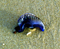
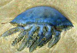
Phylum: Cnidaria
Class: Hydrozoa
Family: Physaliidae
Species: Physalia physalis
"Portuguese Man-of-War"
The Portuguese Man-of-War is a colonial siphonophore. It lacks
swimming capabilities and moves at the mercy of the wind. Its cnidocytes
are lethal to small vertebrates and can be dangerous to humans.
Phylum: Cnidaria
Class: Scyphozoa
Family: Rhizostomeae
"Jellyfish"
This unidentified species is a "true jellyfish" because the
dominant stage in its life history is the medussa stage, not the
polyp stage. These jellyfish were seen in "schools" on the
ferry ride to Stradbroke.
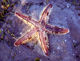
Phylum: Echinodermata
Class: Asteroidea
Family: Astropectinidae
Species: Astropecten polycanthus
Sea stars (starfish) come in many sizes and colors. This
particular species grows to about 12 cm. All have radial symmetry
and often five-fold symmetry. This individual was found in
sea grass on the intertidal flat.
Phylum: Echinodermata
Class: Holothuridea
Species: Stichopus sp.?
Holothurians or "sea cucumbers" feed on the rich organic film that
coats sandy surfaces. They ingest large amounts of sand as they
crawl slowly over the bottom which passes through their
tube-like digestive track and is expelled in a characteristic trail.
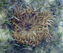
Phylum: Cnidaria
Class: Anthozoa
Family: Cerianthidae
"Tube Anemone"
Sea anemones are in the same phylum as jellyfish. However,
for sea anemones the polyp stage is dominant and the medussa stage
is entirely absent. They have radial symmetry and with their tentacles
they capture prey and draw it toward their mouth.

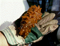
Phylum: Mollusca
Class: Cephalopoda
Family: Octopodidae
Species: Hapalochlaena sp
"Blue-ringed Octopus"
The blue-ringed octopus is quite small, growing to a length of about 7 cm. However,
the blue-ringed octopus has a bite that is poisonous and is capable of killing
humans (hence the glove!). Normally the toxin is used to incapacitate it crab and
shrimp prey.
(Photo J. Chiusolo '99)
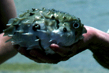
Phylum: Chordata
Subphylum: Vertebrata
Class: Osteichthyes
Family: Diodontidae
Species: Diodon sp
"Porcupine fish"
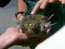 This porcupine fish was caught in the daytime seining at Polka Point.
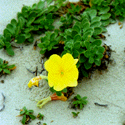
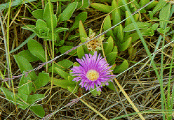
"Beach Primrose"
Beach primrose is one of the plant species that helps to
stabilize the sand dunes along the coast. Their soft
yellow flowers stand out in an area that has little vegetation.
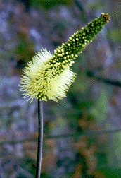
Family: Xanthorrhoeaceae
Species: Xanthorrhoea sp.
"Grass Trees"
Grass trees were encountered at Lamington,
Stradbroke Island, and Carnarvon Gorge. The inflorescence is at the
end of a tall spike often a 1.5 m or greater in length.
Some species are not only
resistant to fire but are actual stimulated to flower by it.
The dry flower-stems
of smaller species were used for spears by aboriginal peoples.
Other Field Sites for the HWS Queensland Term
Student Papers on Terrestrial Topics
Author: Kevin Mitchell (mitchell@hws.edu)
Last Update: 26 June 1997.